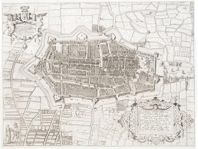
1597 Alkmaar Map: Difference between revisions
Jump to navigation
Jump to search
No edit summary |
No edit summary |
||
| Line 12: | Line 12: | ||
|- | |- | ||
| style="vertical-align: top; width: 133px; height: 15px;" | Source | | style="vertical-align: top; width: 133px; height: 15px;" | Source | ||
| style="vertical-align: top; width: 479px; height: 15px;" | '''[http://tiny.cc/rd6sqx Kaartencollectie UvA]'''|- | | style="vertical-align: top; width: 479px; height: 15px;" | '''[http://tiny.cc/rd6sqx Kaartencollectie UvA]''' | ||
|- | |||
| style="vertical-align: top; width: 133px; height: 15px;" | Source | | style="vertical-align: top; width: 133px; height: 15px;" | Source | ||
| style="vertical-align: top; width: 479px; height: 15px;" | '''[[1597_Alkmaar_Map_enlarge|Closer view]]''' | | style="vertical-align: top; width: 479px; height: 15px;" | '''[[1597_Alkmaar_Map_enlarge|Closer view]]''' | ||
Revision as of 13:05, 8 July 2016
Deze kaart van Alkmaar werd in 1597 door Cornelis Drebbel gegraveerd.
De landmeetkundige gegevens voor deze kaart werden aangeleverd door Adriaen Anthoniszn.
ALCMAER vermaert, leyt wel bewaert Rondt om met Meeren seer pleysant: Oock met schone weyden, zaedland va[n] beyden En veel treffelycke dorpen wel bemant Van elcker cant,comt lyftocht in over vloet: De Soutnering die Stadt oock florere[n] doet
|
| Source | Kaartencollectie UvA |
| Source | Closer view |
| Catalogusnummer | PR 1005036 |
| Uiterlijke vorm | Kaart |
| Plaats | Alkmaar |
| Beschrijving | Plattegrond van Alkmaar, 1597. Titel linksboven met tekst in het Nederlands en wapen van Alkmaar, rechtsonder tekst in het Latijn. |
| Datering | 1597 |
| Vervaardiger | Drebbel, C. |
| Techniek | Kopergravure |
Cost declaration by Adriaen Anthoniszn concerning the survey he made for this map.
<historylink type="back" go="1" style=""></historylink>
